Sea to Sea Dossier
Yarden and Ayelet sleep at Achziv on Wednesday 9 September, walk four days east from the Mediterranean over Har Meron to the Kinneret with a tent, and get home from Ginosar on Sunday 13 September, the second day of Rosh Hashana. Their stage split, the camp rules, the water, the heat, and the Nahal Amud gate times that shape day 3 and day 4.
§1The plan
The common four-day split, sleeping only in the official night camps because the whole line runs through nature reserves. Guidebook times plus about 20 %. Sunset is 18:52 at the start and 18:47 at the end, but the reserves close their trails an hour before it and September afternoons are hot, so walk at first light, 06:00, and be in camp by 15:00. Friday 11 to Sunday 13 September is Shabbat straight into Rosh Hashana: no buses from Friday noon until Sunday night, and full camps. The GPX in your Downloads folder carries these nights, the escapes and every OpenStreetMap tap and spring near the line.
Train to Nahariya → bus 22 → Achziv
Israel Railways to Nahariya, the last station on the coast line; the bus station is across the road. Nateev Express line 22 runs to the Achziv National Park stop about every half hour. Sleep in the Achziv National Park campsite (INPA, paid, book online, showers, no dogs) or for free in the eucalyptus grove behind the Yad LeYad memorial, 800 m north, with a tap at the memorial entrance; Betzet beach further north is the other free option. Buy four days of food in Nahariya: the only shops on the line are the fuel station at Elkosh bridge and the village of Hurfeish on day 2.
Achziv → Nahal Kziv → Montfort → Ein Tamir → Abirim
Feet in the sea at 06:00, then east on farm tracks to the Nahal Kziv reserve at Ein Hardalit (km 8, shaded pools, a tap at the car park). The stream runs all year but INPA says do not drink it: fill at the Yad LeYad tap and at Ein Hardalit. The path climbs to Montfort, the Crusader castle on its spur (km 12, steps and a short scramble, no sleeping in the reserve), drops back to the water and follows it past the Dlavim pool to Ein Tamir (km 16), a spring at the end of a cut tunnel you can wade with a headtorch. Then the one climb of the day: 300 m up past Ein Ziv to the village of Abirim. The night camp is at the village entrance, with a tap and a bin and nothing else. Thursday is a normal day: buses still run on road 89 below the village if something goes wrong; from Friday noon they stop for the holiday weekend. Behind schedule? Goren Park (KKL, free, tap, toilets) sits above Montfort at km 14, 300 m off the line.
Abirim → Elkosh bridge → the springs → Hurfeish → Horbat Hammama
Rolling Galilee hills, no reserve gates. Down to Elkosh bridge on road 89 (km 29, fuel station shop 200 m, the popular unofficial camp there has no water), then up the wadi past a string of small springs: Ein Retet, Ein Tabaat, Ein Zevul and Ein Hotam (km 33, clear and pooled). Hurfeish (km 34) lies 1.5 km north of the line if you need a shop or a cafe; it is a Druze village, open on Friday and on Rosh Hashana. Buses on road 89 stop around 14:00 today for Shabbat and the holiday: from Elkosh bridge onward there is no bus until Sunday night. The afternoon climbs steadily to the foot of Har Meron. Horbat Hammama is the best camp on the trail: tables under the trees, a tap, toilets, and fires allowed in the marked spots. It is also the coolest night, 15–18 °C at 886 m in the open. The Har Meron field school next door has a paid camp with a kitchen and showers if the forecast turns.
Horbat Hammama → Har Meron → Pitul Meron → Nahal Amud night camp
The short day, on purpose: the Nahal Amud reserve admits walkers from Pitul Meron only between 08:00 and 14:30, and closes its trails at 16:00, so the canyon waits for the morning. 300 m of climb from camp to the summit plateau of Har Meron (1,204 m, the highest point west of the Jordan; the peak loop is 15 minutes off the line, tap at the summit car park), then a long descent through Meron's oak forest past Ein Zeved and Ein Meron to Pitul Meron by road 866 (km 49, tables and a tap; Meron Center bus stop 500 m away). From there the trail enters the reserve and reaches the Nahal Amud night camp at the upper entrance in 2.6 km. Saturday is also the first day of Rosh Hashana: the reserve keeps its Saturday hours and the camp will be full, so book it as early as possible; it also sells the reserve ticket you need for day 4. Confirm the holiday gate hours on *3639 when you book. Option B: sleep free at Pitul Meron and enter the reserve at 08:00, which makes day 4 half an hour longer.
Nahal Amud night camp → Sechvi pools → the lower canyon → Ginosar, the Kinneret
The technical day. The reserve opens at 08:00, so this is the one late start. From the camp past Ein Yakim into the upper canyon: six kilometres of ladders, iron pins and handholds beside running water, past the Sechvi pools, to the old flour mill below the Safed industrial zone (km 54, the last bail-out with a bus). Fill 4 L each at the camp tap: INPA forbids drinking from the stream and there is no tap until the lower Nahal Amud camp (km 61, fenced, tap). Then the middle and lower sections, rocky and exposed, bolted in places, drying out as you drop below sea level past the Amud pillar and the caves, to the fish-farm gate and the shore at Ginosar. INPA closes the full canyon on hot days, on rainy days and the day after rain: call *3639 the evening before. Sunday 13 September is the second day of Rosh Hashana: no bus 59 from the Ginosar stop on road 90 until the holiday ends about 19:15, and a thin evening service after it. Arrange a lift or a taxi from Tiberias to Ginosar, or swim at Hukok beach and take the late 59 to Tiberias, then Egged 430 to Haifa or 836 to Tel Aviv.
Faster? The three-day split sleeps at Abirim and Pitul Meron and finishes with a 23 km day through the canyon, which only works with the 08:00 gate and a fast pace. Spare day? Sleep a second night at the lower Nahal Amud camp and swim at Hukok beach (free camping on the grass, showers, shop, no fires).
§2Maps and profile
This map is drawn live from the same GPX you download for OsmAnd, so the two never differ. Tap any line or dot for its note. The layers button toggles the track and each kind of waypoint. "Where am I" shows your position, the kilometre on the route and the distance to the next camp. "Save whole route offline" stores the map tiles in the browser; the page and the GPX are stored automatically, so the site keeps working without signal. Base map OpenTopoMap, a planning aid: carry the SPNI trail map 2, Upper Galilee 1:50,000, or the Israel Hiking Map app.
Annotated section maps, for printing or offline
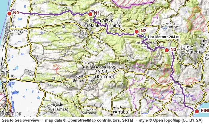
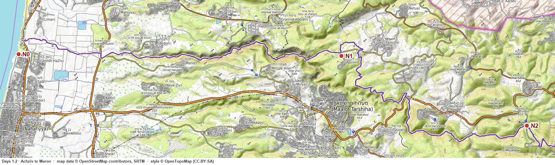 Achziv to Har Meron">
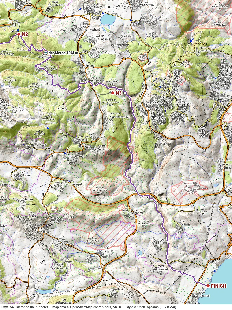 Har Meron to the Kinneret">
§3Rules and water
Reserves: almost the whole line is INPA nature reserve. Sleep only in the night camps. Trails are open from an hour after sunrise to an hour before sunset. No dogs on the trails, no fires outside the marked camp spots, stoves fine.
Nahal Amud (upper section, paid): ticket and registration on parks.org.il. Entry from Pitul Meron 08:00–14:30 (Friday to 13:30), off the trails and the Sechvi pools by 16:00. No night walking. The reserve closes the long trail on hot days, on rain days and the day after rain. Check *3639 the evening before.
Water: INPA says do not drink from Nahal Kziv or Nahal Amud. Taps: Yad LeYad, Ein Hardalit car park, Abirim, Horbat Hammama, Har Meron summit car park, Pitul Meron, the Nahal Amud camp, the lower Nahal Amud camp, Hukok beach. The dry stretch is the canyon: camp tap to the lower camp, 10 km, 4 L each in September. On a sharav day INPA closes the canyon anyway.
| Place | Alt. | Status | Tent | Note |
|---|---|---|---|---|
| Achziv National Park campsite | 5 m | INPA, paid, book online | night 0 | showers, toilets, beach; free: Yad LeYad grove or Betzet beach |
| Goren Park | 220 m | KKL, free, tel 04-9950102 | fallback day 1 | tap, toilets, above Montfort, 300 m off the line |
| Abirim | 546 m | free night camp | night 1 | tap and a bin at the village entrance, no toilets |
| Elkosh bridge | 500 m | unofficial, popular | fallback day 2 | no water; fuel station shop 200 m |
| Horbat Hammama | 886 m | INPA, free, no booking | night 2 | tap, toilets, fire spots; cold; Har Meron field school (paid, kitchen, showers) next door |
| Pitul Meron | 655 m | free night camp | night 3 option B | tables, tap, by road 866, bus stop 500 m |
| Nahal Amud night camp | 530 m | INPA, paid (≈₪40–47 per adult), book online | night 3 | check-in 15:00–19:00, out by 11:00; taps, toilets, electricity; sells the reserve ticket |
| lower Nahal Amud camp | 5 m | free, renovated 2025 | spare night | tap, tent platforms, chemical toilets, fenced; by the road, noisy |
| Hukok north beach | −210 m | declared beach, free on foot | after the finish | grass camping, showers, taps, shop; no fires or barbecues; 1.5 km north of the finish |
§4Technical
Nothing on the line needs a rope, but three parts are hands-on and the reports' injuries happen there. All of it is fine dry and none of it in rain.
| Objective | Where | What it is | Time |
|---|---|---|---|
| Montfort castle | day 1, km 12 | Steep steps and a short rock scramble up the spur to the Crusader ruin, then a steep path back to the stream. Big packs feel it. | on the line, +30 min |
| Ein Tamir tunnel | day 1, km 16 | A cut spring tunnel you can wade to its end with a headtorch; the last metres are a swim. Optional, 20 minutes, leave the packs with a partner. | optional, 20 min |
| Har Meron summit loop | day 3, km 42 | Paved loop around the peak, 1,204 m, view from the Hermon to the Kinneret. The summit itself is a military site. | +15 min |
| Upper Nahal Amud canyon | day 4, km 52–54 | Six kilometres of ladders, iron pins and handholds beside the stream, past the Sechvi pools. Wet rock at the pools. Not for anyone afraid of heights; fine for scramblers. | on the line, ≈3 h |
| Middle and lower Nahal Amud | day 4, km 54–68 | Rocky, exposed, bolted steps in places, then the pillar and the prehistoric caves. Hot in the afternoon; INPA closes it on hot days and after rain. | on the line, ≈4 h |
§5Practical
September
- Coast and Kinneret 30–32 °C by day, 23–25 °C at night; Horbat Hammama at 886 m about 15–18 °C at night. A sharav pushes the coast past 35 °C and the mountains past 30 °C; INPA then closes the Nahal Amud long trail, and one September report gave up in 43 °C. Start at first light and rest through the early afternoon.
- Rain is rare before late September, but a first storm is possible. Rain means no Nahal Amud: the canyon floods, and the reserve bans it on the day and the day after.
- Sunrise ≈06:18, sunset ≈18:50, civil dark ≈19:15. Israel is on summer time until 25 October.
- Live forecast: each day card shows the current Open-Meteo forecast for that day's camp and high point, refreshed on every load, with warnings derived for storms, rain, wind, cold, heat, fog and UV. Open-Meteo forecasts 16 days ahead, so the cards are live for these dates. The last forecast is kept for offline reading.
- Official sources the evening before: Israel Meteorological Service warnings, INPA flood warnings, and the INPA hotline *3639 for Nahal Amud.
Transport
- To the start: train to Nahariya, then Nateev Express 22 (about every 30 min, ≈₪6–9) to the Achziv National Park stop, or a 4 km walk up the coast.
- From the finish: Superbus 59 from the Ginosar stop on road 90 to Tiberias (also stops at Hukok junction), then Egged 430 to Haifa or 836 to Tel Aviv (hourly, ≈2 h), 961/962 to Jerusalem.
- Shabbat runs straight into Rosh Hashana (12–13 September): no buses from Friday 11 September about 14:00 until Sunday 13 September about 19:15. Days 2, 3 and 4 are inside it, so the only bail-out then is a taxi, and the finish needs a lift or the late Sunday buses. Thursday 10 September is a normal day.
- Bail-outs with a bus: Manot-Avdon junction (km 5), Elkosh junction (km 29), Meron Center (km 49), Safed industrial zone (km 54), Kibbutz Hukok (km 66).
Gear
- Sleeping system to 10 °C for Horbat Hammama; the other nights are warm.
- 4 L capacity each; a filter for the springs if a tap fails.
- Four days of food from Nahariya; shop stops at Elkosh bridge and Hurfeish.
- Headtorch for Ein Tamir and the camp evenings. Water shoes or sandals for the pools.
- Sun: hat, 50 SPF, the canyon and the Kinneret drop are exposed.
- Offline maps: OsmAnd with this GPX, plus the Israel Hiking Map app.
- Cash and a printed booking for the Nahal Amud camp and ticket.
- Emergency: 100 police (hikers call 100 and stay put; the Galil-Carmel rescue unit is dispatched), 101 ambulance, 102 fire, INPA *3639.
§6Links
Trip reports and guides
- Shvilist, Hebrew, the stage table, the three- and four-day splits and the camp and water list this plan follows.
- ynet, five days sea to sea, Hebrew, the fullest report: Montfort, the Meron climb, the canyon ladders.
- Hiking in the Holyland, day 1 (20.5 km, 9 h, +628 m) and day 3 (23 km, 12 h from Pitul Meron, the fish-farm gate at the end).
- Outdoors Father, September in 43 °C, abandoned the last 10 km: the heat case.
- Baliletayel, Hebrew, on the upper canyon and on avoiding the holiday crowds.
- Wikivoyage and Hebrew Wikipedia, the trail's history and the old pipe bridge the current line avoids.
- travel-il camp list, Hebrew, community-maintained list of every camp on the line, with the 2025 renovation of the lower Nahal Amud camp.
Official
- INPA Nahal Kziv, INPA Har Meron, INPA Nahal Amud (hours, fees, 04-6999984), INPA Sechvi pools safety page (the Pitul Meron gate times).
- INPA free night camps, INPA camp booking, INPA dog policy, KKL overnight areas.
- IMS warnings, IMS forecast, INPA flood rule.
- Israel Hiking Map, the OpenStreetMap relation this GPX is built from, Moovit, Achziv stop, bus 59 timetable.